Your shopping cart is empty!
Categories
- Radio Communication
- GPS&Fishfinder
-
ALAT SURVEY
- - Aksesoris (Baterai,Tripod,Charger,dll)
- - Alat Geologi
- - Alat Sipil
- - Alat Ukur
- - Brunton
- - Current Meter (Ukur Kecepatan Air&Angin)
- - GPS Geodetik & Mapping
- - LASER LEVEL
- - LUTRON ( Alat Ukur & Laboratorium)
- - Suunto
- - Teropong
- - Theodolite
- - Total Station
- - Waterpass
- - Kompas&Altimeter
- - LaserMeter
- - Camera Trap Bushnell
- Drone DJI
- Lampu LED
- Satellite Phone
- Aksesoris
- Contact Us
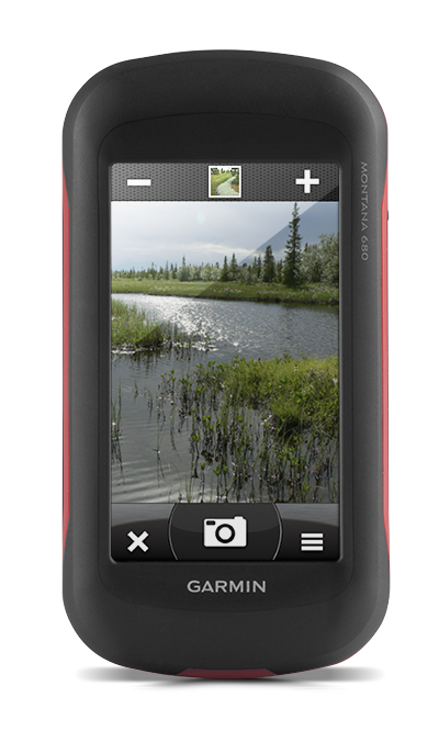
Garmin Montana 680 Glonass GPS

Price: IDR12,000,000

PRODUK Bergaransi Resmi INDONESIA 2 TAHUN BY TAM
Rugged GPS/GLONASS with 8 Megapixel Camera and BirdsEye Subscription
- 4-inch dual-orientation, glove-friendly touchscreen display
- 8 megapixel autofocus camera; automatically geotags photos
- Tracks both GPS and GLONASS satellites
- 1-year BirdsEye Satellite Imagery subscription
- 3-axis compass with barometric altimeter

Take it hiking. Take it hunting. Take it on the water.
Montana 680 features a dual-orientation, color touchscreen that’s glove friendly and includes a 1-year BirdsEye Satellite Imagery subscription. The digital camera provides high-quality images, excellent resolution and automatically geotags photos with coordinates.
Handheld includes 3-axis tilt-compensated compass, barometric altimeter and access to both GPS and GLONASS satellites for improved positioning and typically faster fixes.
Enjoy the View
Montana 680 has a vast 4-inch, sunlight-readable touchscreen display, giving you vivid colors and high-resolution images. Its easy-to-use touchscreen means you’ll spend more time enjoying the outdoors and less time searching for information.
Take Geotagged Pictures
Capture locations and memories with Montana 680’s 8 megapixel digital camera. Each photo is automatically geotagged with coordinates, allowing you to navigate back to that exact spot in the future. Keep track of your photos and see their locations on a map using BaseCamp™. Insert a microSD™ card for more photo storage or to view pictures from other devices.
Physical & Performance |
|
| Physical dimensions | 2.9" x 5.7" x 1.4" (7.48 x 14.42 x 3.64 cm) |
| Display size, WxH | 2"W x 3.5"H (5.06 x 8.93 cm); 4" diag (10.2 cm) |
| Display resolution, WxH | 272 x 480 pixels |
| Display type | bright, transflective 65k color TFT, dual-orientation touchscreen; sunlight readable |
| Touchscreen | |
| Weight | 10.2 oz (289 g) with included lithium-ion battery pack; 11.7 oz (333 g) with 3 AA batteries (not included) |
| Battery | rechargeable lithium-ion (included) or 3 AA batteries (not included); NiMH or Lithium recommended |
| Battery life | up to 16 hours (lithium-ion); up to 22 hours (AA batteries) |
| Water rating | IPX7 |
| High-sensitivity receiver | |
| Interface | high-speed USB and NMEA 0183 compatible |
| Camera |
yes (8 megapixel with autofocus; automatic geo-tagging) |
| Barometric altimeter | |
| Electronic compass | Yes (tilt-compensated 3-axis) |
| Unit-to-unit transfer (shares data wirelessly with similar units) | |
Maps & Memory |
|
| Basemap | |
| Ability to add maps | |
| Built-in memory | 4 GB |
| Accepts data cards | microSD™ card (not included) |
| Custom POIs (ability to add additional points of interest) | |
| Waypoints/favorites/locations | 4000 |
| Routes | 200 |
| Track log | 10,000 points, 200 saved tracks |
Outdoor Features |
|
| Automatic routing (turn by turn routing on roads) | Yes (with optional mapping for detailed roads) |
| Geocaching-friendly | Yes (Paperless) |
| Custom maps compatible | |
| Hunt/fish calendar | |
| Sun and moon information | |
| Tide tables | Yes (with optional Bluechart) |
| Area calculation | |
| Picture viewer | |
Write a review
Your Name:Your Review: Note: HTML is not translated!
Rating: Bad Good
Enter the code in the box below:
Powered By OpenCart
Matahari Electronic © 2024
Matahari Electronic © 2024